Description
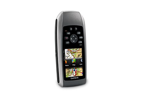
Garmin GPSMAP 78sc. Garmin international is pleased to announce the next generation in marine handhelds: the GPSMAP 78 series. Incorporating a sleek, new design and must-have features, these rugged units are a great fit in Garmin’s best-selling lineup of color marine handhelds and they float! Featuring a bright 2.6-inch LCD color display with built-in basemap and high sensitivity GPS receiver with HotFix, the GPSMAP 78 series takes recreational navigation to a new level. All three models are waterproof, include a built-in microSD card slot for loading additional maps and have a dedicated MOB (man over board) button. The 78sc model includes the sensors, plus it comes preloaded with coastal charts for the United States – including Alaska, Hawaii and Explorer Chart data for the Bahamas. Sensor versions (78s and 78sc) also offer wireless route and waypoint sharing with other compatible units. If you’re looking for the ulitmate high-performance marine handheld, take your pick from the GPSMAP 78 series. Features:. High-sensitivity, WAAS-enabled GPS receiver and HotFix Floats Rugged, waterproof (IEC 60529 IPX7) Worldwide built-in basemap with shaded relief 1.7 GB of internal memory, plus microSD card slot for optional mapping and data storage Wirelessly share thumbnails, routes, tracks, waypoints and geocaches between compatible units Bright 2.6″ LCD sunlight readable color display (160 x 240 pixels) 3-axis compass, provides accurate heading even when the unit is not held level (78s, 78sc) Barometric altimeter tracks pressure changes to pinpoint your precise altitude and to help monitor weather (78s,78sc) High-speed USB interface (78s, 78sc) and NMEA 0183 (GPSMAP 78 series) Up to 20 hours of battery life; battery type: 2AA (not included) NiMH or lithium recommended Weight: 7.7 oz. with batteries. Package Includes:. Unit, USB cable, wrist strap and quick start manual
Make sure this fits by entering your model number.
Marine-friendly handheld with high-sensitivity GPS receiver and 2.6-inch color TFT display
Perfect for boating/watersports–waterproof to IPX7 standards; floats in water
Built-in BlueChart g2 U.S./Bahamas coastal charts with shorelines, depth contours, navaids, harbors, marinas, and more
Built-in 3-axis tilt-compensated electronic compass and barometric altimeter for heading/altitude/weather
Share your waypoints, tracks, routes and geocaches wirelessly with other compatible device user


